
With the crucial need for more housing in Los Angeles, the Community Plan Update process is an important step in providing a long-range vision for land use in each community. Community Plans address a range of topics that shape the quality of life within a neighborhood, including housing and employment, as well as environmental and economic sustainability. Community Plans are guided by the Regional Housing Need Assessment (RHNA) process, which establishes a fair share distribution of affordable housing on a citywide basis. The document is owned and executed by the Los Angeles Planning Department. As stakeholders, we are invited to provide input during the process.
The Planning Department is employing several strategies to allow expansion where housing is permitted through zoning changes, implemented through both the Community Plans and the Housing Element. One of the strategies is to shift growth onto commercial corridors near transit lines to encourage higher-density mixed-use properties, in the hope of creating more walkable and pedestrian-friendly communities. City Planners are also using the plans to introduce elements of the city’s new zoning code, “re:code LA,” which transitions from a traditional zoning system to one that is based on form and frontage districts.
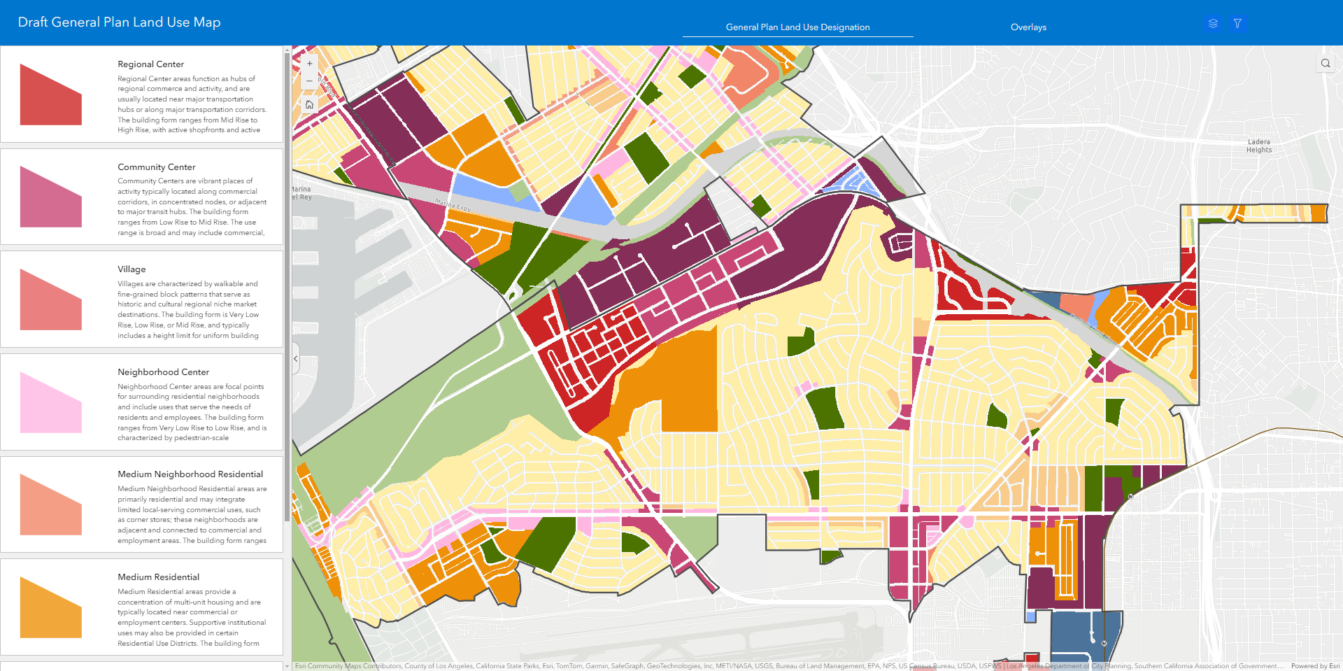
The Westchester/Playa Community Plan process started back in 2019 and has experienced many delays due to the COVID-19 pandemic. Last summer in June 2023, Westchester/Playa residents were digesting new surprises in the release of the Draft 2 residential and commercial maps, which called for more intense upzoning than the maps previously released in 2020. These maps highlighted areas in Kentwood, Westport Heights, Emerson Manor and Osage that are currently single-family and duplex/triplex housing to propose higher density zoning, with up to four units and three stories allowable per R1 lot, and more density in R2 areas. The maps also proposed that all single-family and multi-family zoning along every Westchester corridor should shift to Commercial Zoning, meaning housing up to eight stories could be built in some areas. The community was largely opposed to these proposals, concerned about how this added density would contribute to more traffic, congestion and pollution. Stakeholders who spoke about the city’s proposal at packed neighborhood council meetings held last year, also shared that they were concerned about the detrimental effects on residents’ quality of life.
The Neighborhood Council of Westchester/Playa (NCWP), along with various stakeholder groups, argued that our community faces unique challenges as it serves as a gateway to LAX. Access points to LAX–Manchester, Lincoln, Sepulveda and La Tijera–all have unbearable traffic now at peak hours, which would potentially increase dramatically with intense upzoning. The NCWP also conveyed to city leaders that the Westchester/Playa area already faces reduced air quality due to airport emissions, more noise nuisance and very low canopy coverage due to the hardscape impacts of LAX. With the ongoing modernization of the airport–new terminals, the upcoming Northside Development project and the upcoming addition of the automated people mover–LAX passengers and commuter traffic is only expected to increase. Given these unique challenges to residents, the zoning changes could have a devastating impact on the community, ultimately impeding egress and ingress to a world airport. Other concerns were expressed about the upzoning proposals, especially along the corridors, which could potentially displace hundreds of rent-stabilized residents, in favor of developers offering market-rate rents, an initiative that seems at odds with the City’s goal of creating more affordable housing.
Following the release of the Draft 2 maps, Councilwoman Traci Park’s office provided the opportunity for stakeholders to hold listening sessions with CD 11 planning staff to share their opinions and ideas about the Community Plan. The councilwoman’s office was instrumental in advocating for our community as a liaison to City Planning. In November 2023, the NCWP facilitated a driving tour of Westchester/Playa with city planners, which was instrumental in educating them about the area’s unique challenges. Recently, l.A. City Planning made amendments to its housing incentive ordinance, which stated that the affordable housing and mixed income incentive programs will not apply to single-family housing, although it had initially proposed to include these properties. Over the last few months, city planners went back to the drawing board to revise the maps based on evolving ordinances and community feedback.
The Draft 3 maps were released last month on March 21, and clearly demonstrate that the voices of Westchester/Playa residents were heard. The majority of the residential upzoning proposals were removed from the maps, including the upzoning in Kentwood, Westport Heights, Emerson Manor and Osage. Also deleted from the maps were most of the proposals to upzone the arterials in Westchester/Playa from what is now single-family zoning to commercial mixed-use. While the refined Draft 3 maps better reflect the feedback of Westchester/Playa residents, the revised maps pose new concerns, particularly for residents in Ladera Heights: City Planning is proposing that the current commercial area of Ladera Center (at the corner of La Tijera and La Cienega) be upzoned from “Community Commercial” to “Regional Center” zoning for dense mixed-use, with no height restrictions.
At the March 27 NCWP Community Plan Update Ad Hoc committee meeting, more than 100 concerned Ladera Heights residents attended to voice their opposition to this zoning change. Upset that this would create more traffic in an already very congested area, many speakers shared that they feared this upzoning would allow developers to build more market-rate housing, while possibly removing existing affordable housing. Speakers also shared concerns about creating high-density housing right next to single-family and multi-family homes with no gentle transition; the possible density adding more noise and environmental pollution, and eroding the neighborhood character of this family-oriented community. To complicate matters, this area of Ladera Heights falls into three geographic boundaries and jurisdictions–Los Angeles County, the City of Los Angeles, and Inglewood–making it more difficult for residents to voice concerns to their elected officials. During the meeting, a CD11 staff member told the crowd that the process is ongoing, assuring attendees that they still have time to communicate concerns. A representative from County Supervisor Holly Mitchell’s office was also present, and stated they had just found out about the updated maps and welcomed community feedback.
New to the Draft 3 maps is the proposal to upzone a number of already commercial areas in Westchester, on Century Boulevard, along Sepulveda, La Tijera, and Lincoln, which would transform what is now “Community Commercial” zoning to “Community Center” or “Regional Center.” Another worry expressed by residents is the upzoning of Manchester in Playa del Rey from what is now “Low Medium Residential” with multi-family and small apartment buildings to “Community Center” zoning, for larger-scale mixed-use. This could potentially reduce the number of rent-stabilized units in our geography. Other points expressed by stakeholders involve the possibly inappropriate upzoning on the west side of Pershing due to the coastal zone height restrictions. Further evaluation of these changes in Draft 3 maps must be conducted by the NCWP and the community to identify potential issues.
While it is clear that modifications have been made to the maps that reflect community feedback, there is still work to be done to adequately address the concerns of community stakeholders, particularly in Ladera Heights.
The Westside Community Plan Advisory Group, which was formed in 2023, and is made up of community leaders, residents and local organizations, is poised to add new members this year. They will also be holding meetings and new opportunities to provide input to City Planning, which will help shape the Community Plan Updates for the Westside. The Planning Department hopes to begin the Environmental Impact Report process later this year. The process will last approximately one year to draft and make further amendments. During this period, they will continue to accept stakeholder feedback. The final Community Plan Update will most likely be adopted and implemented in 2025 or 2026.
To stay engaged in the ongoing Community Plan process, be sure to attend the NCWP’s ad hoc committee meetings on the subject on the fourth Monday of each month. Visit ncwpdr.org to for more details.
View the detailed maps at: https://storymaps.arcgis.com/stories/34f75a6be70f4cf0ab9db4a37812ad12
By Cory Birkett.
Cory Birkett is a member of the Neighborhood Council of Westchester/Playa’s Community Plan Update Ad Hoc Committee and a Westchester resident.