

By Cory Birkett and Kimberly Fox, on behalf of the Ad Hoc Community Plan Update Committee of the Neighborhood Council of Westchester/Playa
The Community Plan Update for Westchester/Playa is proposing some zoning changes to parts of our neighborhood that may affect our homes, neighborhood character and daily commutes.
City Planning released the first Draft of the Community Plan Update in July 2020 and recently released a second draft. To help provide feedback and give our community a voice in this important document that will guide building in the area for decades, the Neighborhood Council of Westchester/Playa has created an Ad Hoc committee, which meets the fourth Monday of each month.
As the Community Plan Update progresses, it’s essential for residents to stay informed about the potential zoning changes and how they could impact housing options in Westchester/Playa. With the proposed revisions, some areas may see shifts in density, height restrictions, or even allowances for new types of residential development, all of which could affect the availability and pricing of homes in the neighborhood.
Similarly, housing markets in other regions are also adapting to evolving needs, with affordable and flexible living spaces becoming a priority. For example, provo student housing has seen a rise in innovative listings that cater to the needs of young people seeking budget-friendly options. Whether here or in places like Provo, understanding how these changes influence housing availability can empower communities to voice their concerns and shape the future of their neighborhoods.
Interested in learning more? Read on for a helpful Q&A to help understand more about the Community Plan Update.
Q. What is the Community Plan Update?
A. The Los Angeles City Planning Department is in the process of updating the Westchester/Playa Community Plan, which will be adopted at the same time as three other Westside Community Plans: Venice, Palms-Mar Vista-Del Rey, and West Los Angeles (planning.lacity.org/plans-policies/community-plan-update/planning-westside).
The last plan for Westchester/Playa was adopted in 2004. This update is long overdue and an important step in guiding growth and development standards in our area. An updated Community Plan identifies the specific types of land use and development (residential, commercial and industrial) within the Westchester and Playa del Rey geography.
The Community Plan is important because it identifies and provides for economic opportunities, maintenance of significant environmental resources and seeks to enhance the community identity and unique character of our neighborhood. The document is owned and executed by the Los Angeles City Planning Department. As stakeholders, we are invited to provide input during the Community Plan Update process. Ultimately, our new plan will be adopted by the City Council, rolled into the Housing Element of the City General Plan, and all future development in our area will refer back to this document. Once our new plan is adopted by the City Council, it becomes the guideline for development for every single parcel of land in our geography.
Q. Why is creating more affordable housing an objective of the Community Plan Update?
A. The Los Angeles City Plan’s General Housing Element identifies Los Angeles’s housing needs and opportunities and establishes clear goals to inform future housing decisions. The planning process is utilized to establish a fair share distribution of affordable housing on a citywide basis as informed by the Regional Housing Need Assessment (RHNA) process.
The General Plan also states that we must address lower income housing needs, as a growing percentage of Angelenos now qualify for “affordable housing.” Specifically, Westchester/Playa has been identified as a higher opportunity area, meaning that we have “above average access to health care, services, economic activity, and quality education,” therefore we must take on a “fair share” of housing allocation needs.
Q. What was proposed in the first and second drafts of the Community Plan Update released in 2020 and 2023?
A. The first draft of the Community Plan Update was released in 2020, after which City Planning held sessions to solicit stakeholder feedback.
In a summary of feedback released in 2021, 59 percent of stakeholders in Westchester/Playa strongly disagreed with the first draft’s “Emerging Vision Statement.” Residents expressed concerns about some of the City’s proposed zoning changes for the major corridors of our community. Other concerns included proposed zoning changes leading to the loss of existing affordable housing options and creating inappropriate transitions between dense, high-scale development with lower-scale residential areas. In addition, the housing created by upzoning would not adequately address the affordable housing crisis.
The first draft concepts, now under revision, could introduce mixed-use zoning along Manchester, building off of existing commercial nodes at La Tijera, Sepulveda, Lincoln and Pershing Drive. These corridors are also the major arteries that are used to access LAX, so there is concern that higher density along these streets will result in even more traffic and infrastructure burden.
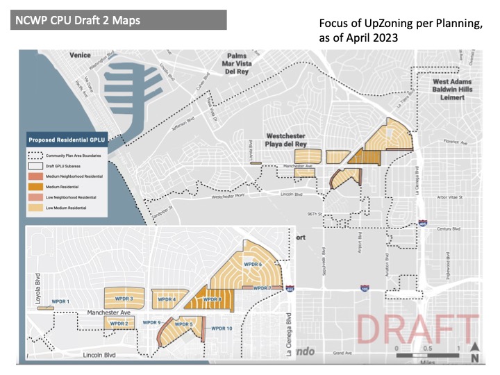
The current Draft 2.0 (planning.lacity.org/plans-policies/community-plan-update/westside-events/westside-community-planning-advisory-group) now undergoing review, is targeting multiple residential zoning changes to R1 single family neighborhoods throughout Westchester. In these areas, City Planning is proposing a zoning change in R1 single family neighborhoods to “Low Medium Residential,” meaning four units with three stories would be allowable per lot. These changes are proposed in the following R1 neighborhoods:
• Kentwood (on Map WPDR 3, between Sepulveda on the east, Emerson to the west, Manchester to the south and 83rd to the north.)
• Westport Heights (on Map WPDR 4, west portion near the La Tijera and Manchester intersection between La Tijera on the east, Sepulveda to the west, 83rd to the north and Manchester to the south.)
• Emerson Manor (on Map WPDR 2, from El Manor to the east, Emerson to the west, Manchester to the north and 88th to the south.)
• Osage north of Manchester (on Map WPDR 6, orientation from corner of Manchester and La Tijera heading east. The northeast edge is La Tijera to the 405. The southeast edge is 85th Place, parallel to Manchester. Then the boundary heads north at Winsford Ave. (next to the Police Academy) until it hits W. 83rd St. going east to La Cienega.)
• Osage South of Manchester (on Map WPDR 5, orientation from corner of Manchester and La Tijera heading south. Manchester defines the north boundary. To the south, at the intersection near La Tijera and Will Rogers Street, which runs northeast defining the lower boundary. At Yorktown Ave., the boundary turns southeast until it ends at Airport Blvd. The portion of Airport Blvd. between Manchester and Lilienthal is the east boundary).
Since this is currently in Draft 2.0 format, any of these proposals are subject to change as the process moves forward. It’s also important to note that State Bill 9 (which took effect in January 2022) makes it currently permissible for an owner or developer to build four units on a single family lot in an existing R1 neighborhood anywhere in California, so these zoning changes would essentially be allowing the same number of units per lot as SB 9.
A more substantial upzoning is proposed for the Triangle area of Osage (on Map WPDR 8, between Airport Blvd., La Tijera and Manchester) from R2 which is currently single family homes and duplexes to “Medium,” which would allow for three to five stories and up to 10 units per lot. Potentially a significant zoning change City Planning proposed in the first draft concepts was elevating Manchester Avenue’s identity to an active, walkable street corridor with retail and housing options. This zoning change has the potential to affect adjacent R1, R2 and R3 neighborhoods currently zoned with single family homes, duplexes and small apartment buildings and allow higher density, mixed-use (housing and retail) development.
One goal of the Community Plan is to create more affordable housing opportunities, and according to feedback, residents felt these zoning changes would actually remove affordable housing options in some of the most diverse neighborhoods by replacing them with mostly market rate units. Other concerns expressed by residents were that these zoning changes would decrease quality of life, increase traffic and decrease property values for residents near zoning changes.
Q. Where are we now in the Community Plan Update process?
A. City Planning is currently working on Draft 2.0 of the Community Plan Update, which they are still refining with the Westside Community Plan Advisory Group. In early 2024, City Planning hopes to begin the Environmental Impact Report process which will last roughly one year to draft and make further amendments. During this period, they will continue to accept stakeholder feedback. The final Community Plan Update will most likely be adopted and implemented sometime in 2025 or 2026.
Q. What is the Neighborhood Council’s Community Plan Update Ad Hoc Committee and why should people get involved?
A. The Neighborhood Council of Westchester/Playa (NCWP) has a committee dedicated to the Community Plan Update. The mission of the committee is to educate and engage Westchester/Playa stakeholders about the process. Updating our plan will involve addressing issues of open space, development, transportation, public services, mobility, safety and maintenance of quality of life, as they relate locally to the neighborhoods that comprise Westchester/Playa.
The Ad Hoc Committee recognizes that Westchester/Playa has unique challenges and circumstances that should be addressed due to our proximity to LAX and the impact the airport has on our local transportation, traffic and infrastructure. With the Silicon Beach hub of Playa Vista to the north, LAX to the south and the largest public beach (Dockweiler) and Ballona Wetlands to the west, we have a responsibility to preserve our natural resources, promote a sustainable environment, and responsibly add more housing (in particular, affordable housing).
The committee welcomes your participation and feedback in regard to how to implement thoughtful and strategic growth in the Community Plan Update while striving to maintain the unique character of Westchester/Playa. The committee meets on the fourth Monday of each month at 6:30 p.m. For more details, please visit the NCWP calendar at ncwpdr.org/calendar.
Cory Birkett and Kimberly Fox are volunteer members of the NCWP Ad Hoc Community Plan Update Committee.